Sandi Spots
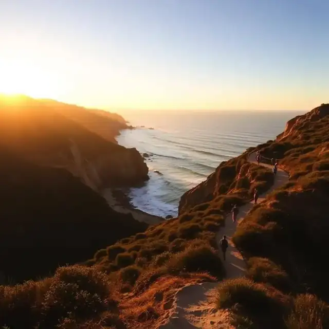
    Rocky chaparral hillside trail winding through Mission Trails Regional Park near San Diego

    Mission Trails Regional Park

    Nearly 8,000 acres of chaparral, a dam, and the busiest summit in the city — all inside city limits.

    Last updated

    Quick answer

    Mission Trails Regional Park covers close to 8,000 acres in the middle of San Diego, about 15 minutes east of downtown, and it is free to enter and free to park. It has four main areas that people treat as separate parks: the visitor center side off Father Junípero Serra Trail, with the easiest walking and the interpretive exhibits; Cowles Mountain, whose Golfcrest Drive staging area feeds the most popular summit hike in the county; the Kwaay Paay and Fortuna peaks in the middle; and the Old Mission Dam historic site along the river. The chaparral offers almost no shade, so the park is a morning or late-afternoon destination from May through October — plan to be off the exposed climbs by 10am in summer and carry more water than feels necessary.

    Main trails at a glance

    TrailDistance / gainDifficulty
    Cowles Mountain (Golfcrest)~3 mi RT, 950 ftModerate, fully exposed
    Kwaay Paay Peak~2 mi RT, 800 ftSteep, quieter
    North Fortuna~5-6 mi RT, 1,100 ftHard
    Father Junípero Serra Trail~3 mi paved, flatEasy, stroller-friendly
    Old Mission Dam loop~1 mi, flatEasy, shaded in parts
    Oak Canyon~3 mi RT, rollingEasy-moderate, seasonal water

    The trails worth your time

    Cowles Mountain

    The highest point in the city of San Diego and the hike everyone does at least once. Roughly a mile and a half up from the Golfcrest staging area with about 950 feet of gain, switchbacking on a wide rocky trail with 360-degree views at the top.

    Local tip: Sunrise is the best time — cooler, the lot has space, and the light over the mesas is the payoff.

    Kwaay Paay Peak

    Steeper and far less crowded than Cowles for a similar reward. It climbs directly from the Father Junípero Serra Trail area with no shade and loose footing on the descent.

    North Fortuna Mountain

    The real workout in the park — a long approach across the valley then a steep push to the summit. Start early and treat it as a half-day.

    Father Junípero Serra Trail

    A flat paved road-turned-trail along the San Diego River between the visitor center and Old Mission Dam. Stroller and wheelchair friendly, and the one part of the park that works midday.

    Old Mission Dam

    A short, mostly flat loop around the 200-year-old Spanish colonial dam, with picnic tables, some shade and water in the river most of the year.

    Oak Canyon

    Rolling single-track with seasonal waterfalls after winter rain and more shade than anywhere else in the park. The trail people recommend once you've done Cowles.

    Parking and staging areas

    All of it is free, but each entrance serves a different part of the park.

    Visitor Center (One Father Junípero Serra Trail)

    The main lot, with restrooms, water, exhibits and the widest trail access. Best first stop if you don't know the park.

    Golfcrest Drive (Cowles Mountain)

    The Cowles trailhead lot in the San Carlos neighborhood. Small and full by 8am on weekends — overflow parks on the residential streets, so read the signs.

    Old Mission Dam lot

    Off Mission Gorge Road at the east end, with picnic areas and the flattest, most family-friendly access.

    East Fortuna / Mast Boulevard

    The staging area for the Fortuna peaks and the equestrian trails, with room to park a trailer.

    Before you go

    • • Rattlesnakes are genuinely common on these trails in warm months — stay on the trail and watch where you put hands and feet.
    • • There is no shade on Cowles, Kwaay Paay or Fortuna. Summer afternoon hikes here produce real heat emergencies every year.
    • • Bring at least a liter per person for Cowles, more for Fortuna. There is no water on the trails.
    • • Dogs are allowed on leash, but hot rock surfaces burn paws — a morning-only rule for dogs from June through September.

    Frequently asked

    Is Mission Trails Regional Park free?

    Yes. Entry and parking at all staging areas are free, and the visitor center is free to enter as well.

    How hard is Cowles Mountain?

    Moderate — about three miles round trip with roughly 950 feet of gain on a wide, rocky, fully exposed trail. Most reasonably fit people do it in 60 to 90 minutes round trip, but the lack of shade is what makes it hard in summer.

    What time should I hike Cowles Mountain?

    Sunrise or the last two hours before sunset. The parking lot fills by 8am on weekends and the trail bakes from mid-morning through late afternoon in summer.

    Are dogs allowed at Mission Trails?

    Yes, on leash, on the trails. Avoid warm-weather middays — the exposed rock gets hot enough to injure paws, and there's no water on the routes.

    Is there a stroller-friendly trail at Mission Trails?

    Yes. The Father Junípero Serra Trail is a flat paved path along the river between the visitor center and Old Mission Dam, and it works for strollers and wheelchairs.

    Keep reading

    The Sandi Spots Newsletter

    San Diego, in your inbox.

    New beach finds, hidden taco shops, weekend events, and seasonal guides — once a week from a local. No spam, ever.

    One email a week. Unsubscribe anytime.

    About this guide

    Written and fact-checked by the Sandi Spots Editorial team — San Diego residents publishing under Sleep Coast LLC. Every place we recommend has been visited in person or verified against an official source, and no business can pay for inclusion or a higher ranking. Last updated .

    Local, first-hand. Reported on the ground in San Diego County.
    Kept current. Prices, hours, and closures reviewed on a rolling basis.
    Independent. Affiliate links never influence rankings.

    Editorial policy · About us · Suggest a correction