Sandi Spots
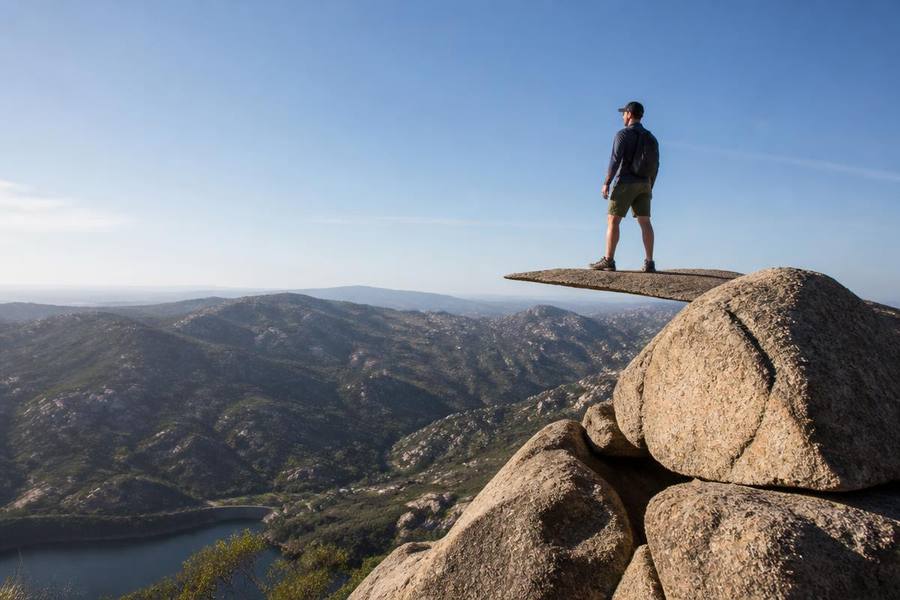
    Hiker standing on the thin granite slab of Potato Chip Rock above San Diego County backcountry hills

    Potato Chip Rock: How to Hike It Without Suffering

    Two routes, real distances, the line at the top, and the timing that separates a great morning from a miserable one.

    Last updated

    Quick answer

    Potato Chip Rock is a thin granite slab near the summit of Mt. Woodson in Poway, and it's the most photographed hike in San Diego County. There are two ways up. From Lake Poway it's roughly 7.5 miles round trip with about 2,000 feet of gain, mostly on trail, and it takes most hikers four to five hours. From the Highway 67 trailhead in Ramona it's about 6 miles round trip on a paved service road — shorter and steeper-feeling, with easier parking but zero shade. Neither route is easy: this is a strenuous hike in full sun with almost no cover, and the exposed granite radiates heat. Go at sunrise, especially May through October, and carry at least two to three liters of water per person. The wait to take a photo on the chip can run 30 to 60 minutes on weekend mid-mornings and is often near zero at 7am on a weekday. Dogs on leash are allowed, but paw burns and heat exhaustion are the most common problems rangers deal with here.

    Potato Chip Rock routes compared

    DistanceGainSurfaceBest for
    Lake Poway route~7.5 mi round trip~2,000 ftDirt trailThe classic route, more scenic
    Highway 67 route (Ramona)~6 mi round trip~1,500 ftPaved service roadShorter, free roadside parking
    Lake Poway loop only~3 miRollingDirt trailSkipping the summit entirely

    Choosing your route

    Lake Poway trailhead

    The classic approach. You start at the lake, take the trail around the shoreline, then climb steadily through boulder fields to the summit ridge. More varied and more shaded in the first mile, but longer, and non-resident parking costs about $10 on peak weekends.

    Local tip: The lot opens early and fills by mid-morning on weekends. If you're not parked by 7:30am in summer, expect to circle.

    Highway 67 trailhead

    A paved maintenance road that climbs relentlessly to the same summit from the Ramona side. Shorter, easier to follow, and parking is free along the highway shoulder — but the pavement bakes and there is no shade at all.

    Which one locals pick

    Fit hikers and photographers favor Lake Poway for the scenery. People with limited time or a dog that needs a shorter day take Highway 67. Both end at the same rock and the same line.

    Timing, crowds, and the line at the rock

    Sunrise starts

    Leave the trailhead at first light. You get cool air, soft light for photos, and often no wait at the chip. This single decision matters more than fitness.

    Weekend mid-morning

    The worst combination: full lots, full sun, and a 30 to 60 minute queue of people waiting their turn to step onto the slab.

    Winter and spring

    December through April is the sweet spot — cooler temperatures, green hills, and long-view visibility to the ocean on clear days after rain.

    Summer reality

    Inland Poway routinely hits the 90s and above. Emergency responses on Mt. Woodson spike in summer heat. If you can't start by 6:30am, pick a different hike.

    What to bring and know

    Water

    Two to three liters per person minimum in warm weather. There is no water on the trail and the last reliable restroom is at the trailhead.

    Sun protection

    Hat, sunglasses, sunscreen, and long sleeves if you burn. The granite reflects heat and light from below as well as above.

    Footwear and grip

    Trail runners or hiking shoes. The final scramble onto the chip involves stepping across a gap onto sloped granite — dry grip matters.

    Dogs

    Allowed on leash, but hot rock burns paws and there's no shade to recover in. If you can't hold your palm on the trail for five seconds, it's too hot for a dog.

    Safety at the rock

    The slab overhangs a real drop. There is no railing, people take turns, and pushing for a photo in a crowd is how injuries happen here.

    Which trailhead to pick, and the parking reality

    There are two routes to Potato Chip Rock and they are not comparable. Choosing wrong turns a moderate morning into a seven-mile ordeal in full sun.

    Mt. Woodson Trail from Lake Poway

    Roughly 7-8 miles round trip with about 2,000 feet of gain. Shadier at the start, steeper in the middle, and the classic route. Non-resident parking fee applies on weekends.

    Local tip: Lake Poway parking is free on weekdays for everyone; the weekend non-resident fee is cash-friendly and modest.

    Mt. Woodson Trail from Highway 67

    About 4-5 miles round trip on a paved service road. Shorter and easier to follow, but almost entirely exposed with no shade and limited roadside parking.

    Local tip: This is the better summer route only if you start before 6:30am — the pavement radiates heat by 9am.

    Parking fills before sunrise on weekends

    Both lots are full by 7-8am on Saturdays and Sundays year-round. The Highway 67 shoulder spots are the first to go.

    Local tip: A Tuesday morning start has a fraction of the cars and almost no line at the rock.

    The line at the rock

    Weekend waits for the photo on the chip regularly run 30-60 minutes. Weekday mornings are often walk-up.

    Local tip: Budget the wait into your water and daylight planning, not just the hiking time.

    Heat, water and doing it safely

    Mt. Woodson is inland, which means it runs 10-20°F hotter than the coast on the same day. Nearly every rescue here is heat-related, not fall-related.

    Bring more water than feels reasonable

    Three liters per person in warm months is the working standard. There is no water on the trail and no shade for the last two miles.

    Local tip: Freeze one bottle overnight — it stays cold through the climb and thaws by the descent.

    Start times by season

    Sunrise start from May through October, and before 8am even in winter if you want parking. Afternoon starts on hot days are how people get in trouble.

    Local tip: Check the inland forecast for Poway, not downtown San Diego — the difference is routinely 15°F.

    Dogs and the summit

    Dogs are allowed on leash but the granite and pavement burn paws, and the final scramble is not dog-friendly.

    Local tip: In summer, leave the dog home and take them to a bay-side trail instead.

    The photo itself

    The chip is a thin granite slab overhanging a drop. There's no railing, and the approach is a short scramble that feels bigger than it looks in photos.

    Local tip: Hand your phone to the next person in line — everyone trades shots, and it's faster than a tripod.

    Frequently asked

    How hard is the Potato Chip Rock hike?

    Strenuous. From Lake Poway it's about 7.5 miles round trip with roughly 2,000 feet of climbing and very little shade, taking most hikers four to five hours. The Highway 67 route is shorter at about 6 miles but is a steady climb on hot pavement.

    How long is the line at Potato Chip Rock?

    On a weekend mid-morning, expect 30 to 60 minutes to wait your turn for a photo. At sunrise on a weekday there is often no line at all.

    Where do you park for Potato Chip Rock?

    Either the Lake Poway recreation area lot, where non-residents typically pay around $10 on peak weekends, or free roadside parking at the Highway 67 trailhead near Ramona. Both lots fill early on weekends.

    Is Potato Chip Rock safe?

    The rock is a natural granite slab with no railing over a significant drop. It's generally safe if you go one at a time, step carefully on dry rock, and don't rush. Most incidents on the mountain are heat-related, not falls.

    When is the best time to hike Potato Chip Rock?

    Sunrise, in the cooler months of roughly November through April. Summer starts should be before 6:30am; midday summer hikes on this trail are genuinely dangerous.

    How long is the Potato Chip Rock hike?

    From Lake Poway it's roughly 7-8 miles round trip with about 2,000 feet of elevation gain, taking most hikers 3.5-5 hours including the photo wait. From the Highway 67 trailhead it's about 4-5 miles round trip on a paved, fully exposed service road.

    Which Potato Chip Rock trailhead is easier?

    The Highway 67 route is shorter and less steep, but it has no shade and very limited roadside parking. The Lake Poway route is longer and harder but has shade early, a real parking lot and water at the trailhead.

    Is parking free at Lake Poway for the Potato Chip Rock hike?

    Parking is free on weekdays. On weekends and holidays, non-Poway residents pay a modest day-use fee at the entrance kiosk, and the lot typically fills between 7am and 8am.

    Can you hike Potato Chip Rock in summer?

    Yes, but start at sunrise. Mt. Woodson runs 10-20°F hotter than the coast, the last two miles have no shade, and heat exhaustion is the most common reason for rescues on this trail. Carry three liters of water per person.

    Keep reading

    The Sandi Spots Newsletter

    San Diego, in your inbox.

    New beach finds, hidden taco shops, weekend events, and seasonal guides — once a week from a local. No spam, ever.

    One email a week. Unsubscribe anytime.

    About this guide

    Written and fact-checked by the Sandi Spots Editorial team — San Diego residents publishing under Sleep Coast LLC. Every place we recommend has been visited in person or verified against an official source, and no business can pay for inclusion or a higher ranking. Last updated .

    Local, first-hand. Reported on the ground in San Diego County.
    Kept current. Prices, hours, and closures reviewed on a rolling basis.
    Independent. Affiliate links never influence rankings.

    Editorial policy · About us · Suggest a correction