May and June
The grayest stretch of the year. Burn-off often waits until 12–2pm at the coast, and on strong-inversion days the beach stays overcast until late afternoon or all day. Inland clears by 9–10am almost every day.
We use cookies for essential site functions and, with your permission, for analytics and advertising. California residents can opt out of the sale or sharing of personal information at any time. See our Privacy Policy, Cookie Policy, and Do Not Sell or Share My Personal Information.
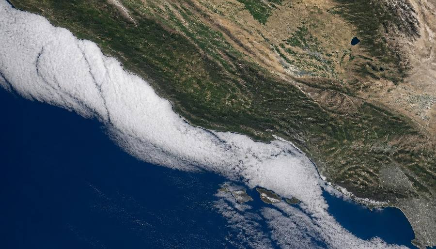
The coastal cloud forecast decoded: when the gray burns off, where it stays longest, and how to pick the sunny side of town.
Last updated
San Diego's marine layer is a shallow deck of cool, moist Pacific air and low clouds that moves inland overnight. It usually clears at the coast between about 10 AM and 2 PM, while inland areas often clear earlier; in May and June, strong inversions can keep beaches gray all day. Today's exact burn-off time varies, and this page does not have a live meteorological feed. Check the National Weather Service San Diego forecast discussion and current beach webcams before deciding whether to wait or drive inland for sun.
| Month | How Common? | Typical Coastal Burn-Off | Inland Conditions |
|---|---|---|---|
| January–March | Occasional | Usually 9–11 AM | Often clear and mild |
| April | Increasing | Usually 10 AM–noon | Clears earlier than the coast |
| May | Very common | Noon–2 PM or later | Often sunny by mid-morning |
| June | Most persistent | Noon–3 PM; sometimes no clearing | Usually sunny away from the coast |
| July | Common early in month | Usually 10 AM–noon | Sunny and warmer |
| August–September | Least common | By 9–10 AM when present | Mostly sunny |
| October–December | Occasional | Usually 9–11 AM | Clear during offshore flow |
Today's exact burn-off time varies, and Sandi Spots does not publish a live daily estimate. The typical coastal window is 10 AM to 2 PM, but a strong May or June inversion can hold clouds all day. Use the live NWS forecast discussion and beach webcams for the current answer.
The grayest stretch of the year. Burn-off often waits until 12–2pm at the coast, and on strong-inversion days the beach stays overcast until late afternoon or all day. Inland clears by 9–10am almost every day.
Still cloudy some mornings, but the sun usually wins by 11am–12pm at the beach. The pattern starts breaking down mid-month.
The sunniest coastal months. Any overnight clouds typically burn off by 9–10am, and many days start clear from sunrise.
A thinner, weaker marine layer. When it shows up it usually lifts by 9–11am; Santa Ana events bring multi-day stretches of all-day coastal sunshine.
Webcams at La Jolla Cove, Crystal Pier in Pacific Beach, Mission Beach, and downtown show the actual sky. The NWS San Diego forecast discussion often describes marine-layer depth and expected clearing.
The marine layer is a local version of advection fog. It forms when cool ocean air moves over warmer coastal land and water, condensing into low clouds.
The California Current keeps near-shore water temperatures in the 60s for much of the year. That cools the air directly above it.
Inland heating forms a layer of warm air a few thousand feet up. The cool marine air cannot rise through it, so it spreads horizontally as a cloud deck.
Sea breezes and the pressure gradient between cool ocean and hot desert drive the marine layer into coastal valleys at night.
As the sun warms the ground, the lower air rises and mixes with the warmer air above, dissolving the cloud deck from below.
Coastal mountains act as a wall. The marine layer piles up against them and rarely climbs much above 2,000 to 3,000 feet.
When a strong high-pressure system sits inland and the ocean stays cool, the pattern can repeat for a week or more.
Most weather apps give you temperature and a generic cloud icon. For marine layer, you need a few more signals.
A visible satellite image shows the white cloud deck in real time. If it is solid from the coast to the mountains, burn-off will be slow.
Sounding data from San Diego or Miramar shows the temperature profile. A strong inversion means the clouds are trapped.
A large difference between coastal and inland pressure drives stronger onshore flow and a deeper marine layer.
La Jolla Cove, Mission Beach, Crystal Pier, and downtown San Diego webcams show the actual sky right now.
The NWS San Diego forecast discussion specifically mentions marine layer depth and burn-off timing most mornings.
If the airport is forecasting 64°F and cloudy while Escondido is forecasting 82°F and sunny, the marine layer is the reason.
The marine layer is hyperlocal. On a gray coastal morning, you often have sunny options within a 20-minute drive.
These inland valleys are far enough from the ocean and low enough in elevation to clear early and stay sunny.
Del Mar Heights, Rancho Santa Fe, and parts of La Jolla sit above the typical cloud deck and can be sunny while the beach is gray.
If you do not want to drive, the marine layer usually burns off between 11am and 2pm. Afternoon beach plans are safer.
Beaches with direct exposure to the northwest wind, like parts of Pacific Beach and Ocean Beach, often hold the marine layer longest.
Some local services break forecasts down by neighborhood. Use those instead of a single city-wide forecast.
August through October is the most reliable coastal sunshine. May and June are the least reliable.
The marine layer is a shallow layer of cool, moist air and low clouds that forms over the Pacific Ocean and moves inland, especially at night. It is most common near the coast and usually burns off as the day warms.
On most days it burns off between 10am and 2pm. On days with a strong temperature inversion, it may persist all day at the coast.
The cool ocean keeps coastal air moist and cloudy, while inland heating creates a warm air cap that traps the clouds near the coast. Inland areas warm up enough to stay clear.
Check visible satellite imagery, local webcams, the NWS forecast discussion, and the temperature difference between the coast and inland. A strong west wind and a warm inland afternoon usually mean a gray next morning.
Yes, but it is usually weaker and burns off faster. The strongest and most persistent marine layer occurs in late spring and early summer.
Sometimes. Low clouds and fog at San Diego International Airport can reduce visibility and cause delays, especially in the early morning.
The hub for understanding San Diego's seasonal quirks, from marine layer to Santa Ana winds.
Why the coast goes gray for weeks and how to plan around it.
The hot, dry winds that reshape fire risk, allergies, and beach days.
What to stock, secure, and know before the next shaker.
When the highest tides of the year flood beaches, piers, and roads.
Why the coast stays gray for weeks in late spring.
Monthly averages and what to expect through the year.
Check La Jolla, Mission Beach and Pacific Beach before leaving.
Compare coastal conditions, parking and the best beach for your day.
An inland alternative when the coast stays gray.
The Sandi Spots Newsletter
New beach finds, hidden taco shops, weekend events, and seasonal guides — once a week from a local. No spam, ever.
One email a week. Unsubscribe anytime.
Published by the Sandi Spots Editorial team at Sleep Coast LLC. Guides combine local perspective and source research. Check the individual guide for firsthand observations and follow official links to confirm current details.